−CONTENTS−
- Site description -
The measurements has started since May 2001 in a low-storied residential
area in Kugahara, Tokyo,
Japan (35o34’N, 139o41’E). The instruments were attached to a 29-m
tower installed
in a backyard to one of the homes.
The residential area mainly consists of densely
built-up houses, paved roads, and
small playgrounds. According to our image analysis over the area using Geographic
Information System (GIS) data produced by Tokyo metropolitan government, within
500-m of the tower the percentage of ground area covered by buildings was
32.6% and the total green cover ratio was about 20.6%.
The vegetation is scattered in backyards and playgrounds in the residential
area. Gentle terrain and rows of houses homogeneously extends at least 1-km to
the south, west, and north from the tower. The terrain within 200-m to
the east is gently slanting down with an inclination angle of 5.7o.
At the foot of the slope, light industrial factories and higher multistory
apartments are mixed with residential homes but their roof level is almost same
as the canopy top around the tower. By averaging the heights of 660 buildings
within 500-m of the tower, we determined that the
mean building height is 7.3 m and the standard deviation is about ±1.3 m.
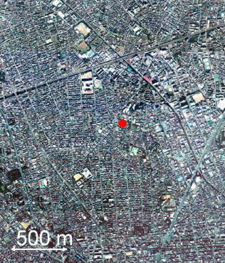
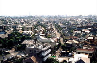
Table 1 Land cover properties at the study site.
|
Building height |
zH |
7.3 m (Std. 1.3 m) |
|
Areal fraction covered by buildings |
lp |
32.6% |
|
Areal fraction covered by vegetation |
lV |
20.6% |
|
Areal fraction of impervious space (paved road + concrete) |
lI |
38.3% (26.2% + 12.1%) |
|
Areal fraction of pervious space (playground except for vegetation) |
lG |
8.5% |
Std is the standard deviation.
Introduction
Site Information
Instruments
Publication
Research
Data Archive
Link